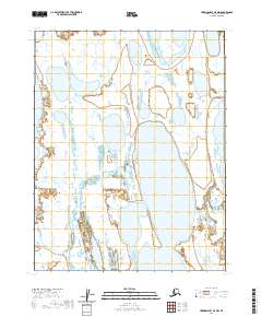
2020 Map of Harrison Bay C-5 NW
USGS Topo · Published 2020About this map
Garry Creek meanders through the heart of the North Slope's coastal lowlands in this recent geospatial survey. The landscape is defined by the complex hydrology of the Arctic tundra, where countless unnamed ponds and wetlands dominate the terrain between the creek and the coastal margins of Harrison Bay. The map clearly delineates the Public Land Survey System boundaries, including t16n r4w and t15n r4w, which organize this largely untouched wilderness. While human settlements are absent, the map provides precise data on the shifting hydrography and elevation of this sensitive environment as it appeared in the early 21st century.
Find a feature on this map
5 named features on this map. Tap any name to fly to it.
Don’t see what you’re looking for? This feature index may not catch every label — zoom into the map to look around manually.
Map Details
Editions of this 2020 Harrison Bay C-5 NW Map
This is the sole edition of this map. No revisions or reprints were ever made.
Other maps of this area

1951 · Harrison Bay
USGS Topo · 1:250,000

1951 · Teshekpuk
USGS Topo · 1:250,000

1955 · Harrison Bay
USGS Topo · 1:250,000

1955 · Teshekpuk
USGS Topo · 1:250,000

1955 · Harrison Bay C-5
USGS Topo · 1:63,360

1955 · Harrison Bay D-5
USGS Topo · 1:63,360

1955 · Teshekpuk D-1
USGS Topo · 1:63,360
1955 · Teshekpuk C-1
USGS Topo · 1:63,360

1962 · Harrison Bay C-5
USGS Topo · 1:50,000
1962 · Harrison Bay D-5
USGS Topo · 1:50,000