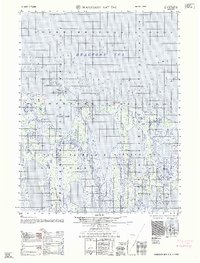
1962 Map of Harrison Bay D-5
USGS Topo · Published 1962About this map
Naval Petroleum Reserve No 4 dominates this 1962 Arctic landscape, reflecting a mid-century period of strategic resource exploration along Alaska's northern coast. The sheet details a complex transition from land to water, where the coastal margins of the Beaufort Sea meet a network of lakes and tundra. Key geographic markers such as Pitt Point, Cameron Point, and Pogik Point define the jagged shoreline surrounding Pogik Bay. These sounding and hydrographic details were compiled from 1956 coastal charts and 1955 aerial photography, providing a precise look at the shifting sand bars and gravel spits of the Harrison Bay region during the early Cold War era.
Find a feature on this map
6 named features on this map. Tap any name to fly to it.
Don’t see what you’re looking for? This feature index may not catch every label — zoom into the map to look around manually.
Map Details
Editions of this 1962 Harrison Bay D-5 Map
This is the sole edition of this map. No revisions or reprints were ever made.
Other maps of this area

1951 · Harrison Bay
USGS Topo · 1:250,000

1951 · Teshekpuk
USGS Topo · 1:250,000

1955 · Harrison Bay
USGS Topo · 1:250,000

1955 · Teshekpuk
USGS Topo · 1:250,000

1955 · Harrison Bay D-4
USGS Topo · 1:63,360

1955 · Harrison Bay C-5
USGS Topo · 1:63,360

1955 · Harrison Bay D-5
USGS Topo · 1:63,360

1955 · Teshekpuk D-1
USGS Topo · 1:63,360

1955 · Harrison Bay C-4
USGS Topo · 1:63,360
1955 · Teshekpuk C-1
USGS Topo · 1:63,360