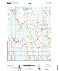
2020 Map of Harrison Bay C-5 SW
USGS Topo · Published 2020About this map
Teshekpuk Lake dominates the western edge of this 2020 topographic map, documenting the shifting aquatic landscape of Alaska's North Slope. The terrain is characterized by a dense network of thaw lakes and wetlands, which flow eastward via Garry Creek and the Kogru River. These water systems represent the primary geographic features within the township boundaries of t15n r4w and t14n r4w. As a contemporary study of Arctic hydrology, the map provides precise data on the drainage patterns and shoreline configurations that define this region of the North Slope. The absence of man-made structures or roads emphasizes the isolation of this landscape, where the seasonal movement of water across the tundra is the principal agent of change. Researchers can examine the intricate connections between the larger basins and the smaller unnamed pools that saturate the borough.
Find a feature on this map
9 named features on this map. Tap any name to fly to it.
Don’t see what you’re looking for? This feature index may not catch every label — zoom into the map to look around manually.
Map Details
Editions of this 2020 Harrison Bay C-5 SW Map
This is the sole edition of this map. No revisions or reprints were ever made.
Other maps of this area

1951 · Harrison Bay
USGS Topo · 1:250,000

1951 · Teshekpuk
USGS Topo · 1:250,000

1955 · Harrison Bay
USGS Topo · 1:250,000

1955 · Teshekpuk
USGS Topo · 1:250,000

1955 · Teshekpuk B-1
USGS Topo · 1:63,360

1955 · Harrison Bay C-5
USGS Topo · 1:63,360

1955 · Harrison Bay B-5
USGS Topo · 1:63,360
1955 · Teshekpuk C-1
USGS Topo · 1:63,360

1962 · Harrison Bay C-5
USGS Topo · 1:50,000

1964 · Teshekpuk
USGS Topo · 1:250,000