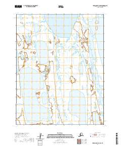
2020 Map of Harrison Bay D-5 SW
USGS Topo · Published 2020About this map
Pogik Bay and the surrounding coastal tundra dominate this 2020 topographic record of Alaska's North Slope. The area is defined by the Public Land Survey System grids of t18n r4w and t17n r4w, illustrating the vast, unpopulated wetland complexes that characterize this remote Arctic region. The landscape is a intricate network of thaw lakes and coastal marshes typical of the Beaufort Sea shoreline, preserved here as they appeared in the early 21st century. This map serves as a vital document for understanding the drainage patterns and shoreline morphology of the Alaskan coast before further climatic shifts alter these delicate hydrologic features.
Find a feature on this map
7 named features on this map. Tap any name to fly to it.
Don’t see what you’re looking for? This feature index may not catch every label — zoom into the map to look around manually.
Map Details
Editions of this 2020 Harrison Bay D-5 SW Map
This is the sole edition of this map. No revisions or reprints were ever made.
Other maps of this area

1951 · Harrison Bay
USGS Topo · 1:250,000

1951 · Teshekpuk
USGS Topo · 1:250,000

1955 · Harrison Bay
USGS Topo · 1:250,000

1955 · Teshekpuk
USGS Topo · 1:250,000

1955 · Harrison Bay C-5
USGS Topo · 1:63,360

1955 · Harrison Bay D-5
USGS Topo · 1:63,360

1955 · Teshekpuk D-1
USGS Topo · 1:63,360
1955 · Teshekpuk C-1
USGS Topo · 1:63,360

1962 · Harrison Bay C-5
USGS Topo · 1:50,000
1962 · Harrison Bay D-5
USGS Topo · 1:50,000