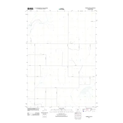
2012 Map of Harrold NW
USGS Topo · Published 2012About this map
Medicine Knoll Cr winds through this rural section of Sully County, marking the primary natural drainage in a landscape defined by its rigid section-line road network. The map reveals an agrarian layout where transportation is dictated by a grid of corridors such as 321st Ave and 324th Ave, reflecting the systematic settlement of the Great Plains. These routes, including 183rd St and 185th St, provide access to scattered homesteads and agricultural operations across the high prairie. The sparse distribution of buildings and the concentration of water features along the creek suggest a geography where land use is closely tied to the few available riparian corridors.
Find a feature on this map
16 named features on this map. Tap any name to fly to it.
Don’t see what you’re looking for? This feature index may not catch every label — zoom into the map to look around manually.
Map Details
Editions of this 2012 Harrold NW Map
This is the sole edition of this map. No revisions or reprints were ever made.
Other maps of this area

1953 · Huron
USGS Topo · 1:250,000

1954 · Huron
USGS Topo · 1:250,000

1967 · Blunt SE
USGS Topo · 1:24,000

1967 · Blunt NE
USGS Topo · 1:24,000

1968 · Harrold NW
USGS Topo · 1:24,000

1968 · Harrold
USGS Topo · 1:24,000

1968 · Holabird
USGS Topo · 1:24,000

1968 · Harrold NE
USGS Topo · 1:24,000

1974 · Gettysburg Municipal Airport SE
USGS Topo · 1:24,000
1978 · Thomas Lake
USGS Topo · 1:24,000