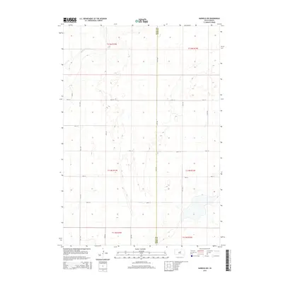
2015 Map of Harrold NW
USGS Topo · Published 2015About this map
Medicine Knoll Cr carves a winding path across the northwestern corner of this landscape, marking the primary drainage through the rolling prairies of central South Dakota. The terrain is defined by a grid of section lines and gravel roads that delineate the transition between Sully County and Hyde County. This 2015 survey reveals a classic Great Plains land-use pattern where rural homesteads and agricultural operations are reached via long stretches of unpaved roads like 321st Ave and 324th Ave. The map identifies the precise boundary between multiple townships, including t115n r74w and t114n r73w, providing a clear record of modern property and administrative divisions in this sparsely settled region. Small, unnamed depressions and water catchments are scattered throughout, illustrating the natural prairie potholes characteristic of the area.
Find a feature on this map
20 named features on this map. Tap any name to fly to it.
Don’t see what you’re looking for? This feature index may not catch every label — zoom into the map to look around manually.
Map Details
Editions of this 2015 Harrold NW Map
This is the sole edition of this map. No revisions or reprints were ever made.
Other maps of this area

1953 · Huron
USGS Topo · 1:250,000

1954 · Huron
USGS Topo · 1:250,000

1967 · Blunt SE
USGS Topo · 1:24,000

1967 · Blunt NE
USGS Topo · 1:24,000

1968 · Harrold NW
USGS Topo · 1:24,000

1968 · Harrold
USGS Topo · 1:24,000

1968 · Holabird
USGS Topo · 1:24,000

1968 · Harrold NE
USGS Topo · 1:24,000

1974 · Gettysburg Municipal Airport SE
USGS Topo · 1:24,000
1978 · Thomas Lake
USGS Topo · 1:24,000