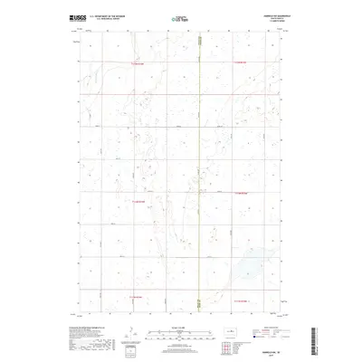
2017 Map of Harrold NW
USGS Topo · Published 2017About this map
Medicine Knoll Cr winds through the northwest corner of this prairie landscape, defining the local hydrology in an area otherwise characterized by intermittent wetlands and seasonal basins. Located along the eastern edge of Sully County, the map documents the Sully Co Hyde Co boundary as it stood in 2017. The terrain is organized by a grid of rural roads and section lines, including Co Rd 649 and 321st Ave, which provide access to the vast agricultural allotments and cattle grazing lands of central South Dakota. The survey highlights a sparse settlement pattern typical of the High Plains, where human presence is primarily marked by long straightaways such as 185th St and 189th St. The mapping of these land divisions offers a clear view of the modern rural infrastructure and natural drainage patterns in the Missouri Plateau region.
Find a feature on this map
22 named features on this map. Tap any name to fly to it.
Don’t see what you’re looking for? This feature index may not catch every label — zoom into the map to look around manually.
Map Details
Editions of this 2017 Harrold NW Map
This is the sole edition of this map. No revisions or reprints were ever made.
Other maps of this area

1953 · Huron
USGS Topo · 1:250,000

1954 · Huron
USGS Topo · 1:250,000

1967 · Blunt SE
USGS Topo · 1:24,000

1967 · Blunt NE
USGS Topo · 1:24,000

1968 · Harrold NW
USGS Topo · 1:24,000

1968 · Harrold
USGS Topo · 1:24,000

1968 · Holabird
USGS Topo · 1:24,000

1968 · Harrold NE
USGS Topo · 1:24,000

1974 · Gettysburg Municipal Airport SE
USGS Topo · 1:24,000
1978 · Thomas Lake
USGS Topo · 1:24,000