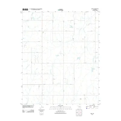
2012 Map of Hart
USGS Topo · Published 2012About this map
The rural community of Hart sits at the center of a complex network of tributaries within Pontotoc County, where the landscape is defined by the winding paths of Canadian Sandy Cr and its many branches. This 2012 survey reveals a transition from traditional agricultural patterns to modern resource management, evidenced by the series of reservoirs such as Sandy Cr Site 14 Reservoir and Sandy Cr Site 10 Reservoir that dot the countryside. For those tracing local history, the map preserves the locations of Corley Cem and Hart Cem, providing essential points of reference for genealogical research in this sparsely populated region. The southern reaches of the quadrangle are marked by industrial activity at the Dolberg Oil Field, while the terrain is dissected by numerous seasonal watercourses including Cherokee Sandy Cr, Hogskin Cr, and Big Sandy Cr.
Find a feature on this map
38 named features on this map. Tap any name to fly to it.
Don’t see what you’re looking for? This feature index may not catch every label — zoom into the map to look around manually.
Map Details
Editions of this 2012 Hart Map
This is the sole edition of this map. No revisions or reprints were ever made.
Other maps of this area

1898 · Pauls Valley
USGS Topo · 1:125,000

1901 · Stonewall
USGS Topo · 1:125,000

1902 · Pauls Valley
USGS Topo · 1:125,000

1957 · Ardmore
USGS Topo · 1:250,000

1963 · Ardmore
USGS Topo · 1:250,000

1964 · Byars
USGS Topo · 1:24,000

1965 · Pauls Valley NE
USGS Topo · 1:24,000

1965 · Davis
USGS Topo · 1:24,000

1967 · Roff South
USGS Topo · 1:24,000
1967 · Vanoss
USGS Topo · 1:24,000