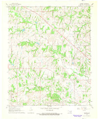
1967 Map of Vanoss
USGS Topo · Published 1968About this map
The Maxwell Oil and Gas Field dominates the northern landscape of this Oklahoma survey, highlighting the energy-driven economy that shaped the region by the mid-1960s. Small community clusters like Oil Center and Bebee underscore the localized settlement patterns that grew around these industrial sites. To the south, the village of Vanoss sits near the tracks of the Atchison Topeka and Santa Fe railroad, which provided vital transport through the undulating terrain of the Canadian River valley. This document captures a transition between the established agricultural life and modern industrial extraction, preserving the locations of rural landmarks such as Moss Cem, Center Cem, and the Freewill Baptist Ch that served generations of local families. The presence of the Chickasaw and Midland boundaries reflects the complex administrative and tribal history of Pontotoc County.
Find a feature on this map
25 named features on this map. Tap any name to fly to it.
Don’t see what you’re looking for? This feature index may not catch every label — zoom into the map to look around manually.
Map Details
Editions of this 1967 Vanoss Map
2 editions found
Other maps of this area

1901 · Stonewall
USGS Topo · 1:125,000

1957 · Ardmore
USGS Topo · 1:250,000

1958 · Ada
USGS Topo · 1:24,000

1958 · Vamoosa
USGS Topo · 1:24,000

1958 · Konawa
USGS Topo · 1:24,000

1963 · Ardmore
USGS Topo · 1:250,000

1966 · Asher
USGS Topo · 1:24,000

1967 · Ahloso
USGS Topo · 1:24,000
1967 · Stratford
USGS Topo · 1:24,000

1967 · Roff North
USGS Topo · 1:24,000