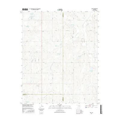
2016 Map of Hart
USGS Topo · Published 2016About this map
Hart sits at the intersection of Garvin, Pontotoc, and Murray counties, serving as a focal point for this rural Oklahoma landscape. The area is defined by a dense network of water management features, including numerous flood control structures such as the Cherokee Sandy Site 8d Reservoir and Sandy Cr Site 14 Reservoir. These reservoirs are integrated into the complex drainage systems of Canadian Sandy Cr and its various tributaries like Little Canadian Sandy Cr and Cherokee Sandy Cr. Local history is anchored by the Hart Cem and Corley Cem, which provide essential touchstones for genealogical research in this tri-county border region. The terrain is marked by the branching paths of Big Sandy Cr and Guy Sandy Cr, illustrating the hydrological importance of the Arbuckle Mountain foothills region.
Find a feature on this map
58 named features on this map. Tap any name to fly to it.
Don’t see what you’re looking for? This feature index may not catch every label — zoom into the map to look around manually.
Map Details
Editions of this 2016 Hart Map
This is the sole edition of this map. No revisions or reprints were ever made.
Other maps of this area

1898 · Pauls Valley
USGS Topo · 1:125,000

1901 · Stonewall
USGS Topo · 1:125,000

1902 · Pauls Valley
USGS Topo · 1:125,000

1957 · Ardmore
USGS Topo · 1:250,000

1963 · Ardmore
USGS Topo · 1:250,000

1964 · Byars
USGS Topo · 1:24,000

1965 · Pauls Valley NE
USGS Topo · 1:24,000

1965 · Davis
USGS Topo · 1:24,000

1967 · Roff South
USGS Topo · 1:24,000
1967 · Vanoss
USGS Topo · 1:24,000