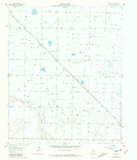
1963 Map of Hart NW
USGS Topo · Published 1981About this map
North Fork Running Water Draw carves a subtle path through this High Plains landscape, reflecting a regional reliance on underground water sources and strategic drainage. The agricultural character of Castro County is evident through the presence of specialized facilities like the Feedlot and the various excavations including a Borrow Pit and Gravel Pit. Transportation and commerce in the early 1960s were anchored by the Fort Worth and Denver railroad, which cuts diagonally across the terrain, linking small trackside points like Mulkey to the larger regional network. Near the southern edge, the settlement of Hart serves as a local hub, supported by the presence of the Hart Cem. The map's contour lines and numerous wells suggest the intensive hydrological management managed by the High Plains Underground Water Conservation District during this era of Texas ranching and farming expansion.
Find a feature on this map
9 named features on this map. Tap any name to fly to it.
Don’t see what you’re looking for? This feature index may not catch every label — zoom into the map to look around manually.
Map Details
Editions of this 1963 Hart NW Map
2 editions found
Other maps of this area

1954 · Clovis
USGS Topo · 1:250,000

1958 · Clovis
USGS Topo · 1:250,000

1962 · Dodd NE
USGS Topo · 1:24,000

1963 · Hart NW
USGS Topo · 1:24,000

1963 · Dodd SE
USGS Topo · 1:24,000

1963 · Hart SW
USGS Topo · 1:24,000

1965 · Dimmitt
USGS Topo · 1:24,000

1965 · Hart
USGS Topo · 1:24,000

1965 · Nazareth SW
USGS Topo · 1:24,000

1965 · Hilburn
USGS Topo · 1:24,000