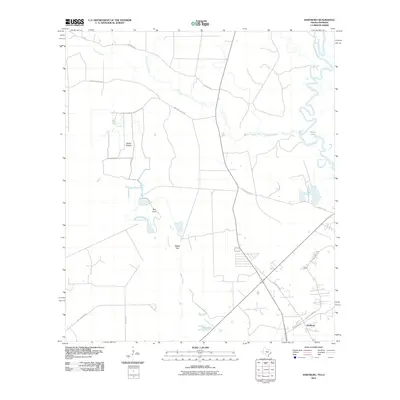
2010 Map of Hartburg
USGS Topo · Published 2010About this map
Hartburg anchors the southeast corner of this survey, situated just west of the winding Sabine River at the Texas-Louisiana border. The landscape is defined by its complex hydrology, where Cypress Creek and Little Cypress Creek drain toward the river through low-lying areas such as Blacks Prairie and Bull Cove. The distribution of local infrastructure, including Ebner Rice Field Dr, suggests a rural economy tied to the land and water management. Further west, Adams Bayou passes near Maple Gap, illustrating the intricate network of tributaries that shape this corner of Newton County. Traces of older transport routes are evident in the Old State Hwy 87 and Stephens Cutoff, which provide a look at the area's connectivity before modern highway expansions altered the local road network.
Find a feature on this map
18 named features on this map. Tap any name to fly to it.
Don’t see what you’re looking for? This feature index may not catch every label — zoom into the map to look around manually.
Map Details
Editions of this 2010 Hartburg Map
This is the sole edition of this map. No revisions or reprints were ever made.
Other maps of this area

1926 · Texla
USGS Topo · 1:24,000

1926 · Mauriceville
USGS Topo · 1:24,000

1932 · Orange
USGS Topo · 1:62,500

1943 · Mauriceville
USGS Topo · 1:24,000

1943 · Texla
USGS Topo · 1:24,000

1947 · Starks
USGS Topo · 1:31,680

1947 · Toomey
USGS Topo · 1:31,680

1947 · Carter Creek
USGS Topo · 1:31,680

1952 · Lake Charles
USGS Topo · 1:250,000
1954 · Toomey
USGS Topo · 1:31,680