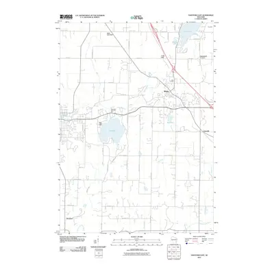
2010 Map of Hartford East
USGS Topo · Published 2010About this map
Slinger serves as the central hub of this Wisconsin landscape, where several major transit corridors converge near the Rubicon River. The area is characterized by its glacial hydrology, featuring significant water bodies such as Pike Lake, which is regulated by the Pike Lake Dam, and the northern reach of Cedar Lake. These lakes are joined by smaller basins like Mueller Lake and Mud Lake, creating a complex network of wetlands and drainage points including the Ashippun River and Coney River.
Find a feature on this map
50 named features on this map. Tap any name to fly to it.
Don’t see what you’re looking for? This feature index may not catch every label — zoom into the map to look around manually.
Map Details
Editions of this 2010 Hartford East Map
This is the sole edition of this map. No revisions or reprints were ever made.
Other maps of this area

1892 · Waukesha
USGS Topo · 1:62,500

1892 · Oconomowoc
USGS Topo · 1:62,500

1901 · Waukesha
USGS Topo · 1:62,500

1904 · West Bend
USGS Topo · 1:62,500

1904 · Hartford
USGS Topo · 1:62,500

1906 · Waukesha
USGS Topo · 1:62,500

1909 · Oconomowoc
USGS Topo · 1:62,500

1957 · Madison
USGS Topo · 1:250,000

1959 · West Bend
USGS Topo · 1:62,500
1959 · Stonebank
USGS Topo · 1:24,000