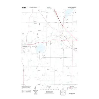
2013 Map of Hartford East
USGS Topo · Published 2013About this map
Hartford and Slinger anchor this portrait of Washington County, where the transition from agricultural traditions to suburban development is visible. The landscape is defined by its glacial hydrology, centered on the prominent Pike Lake and Cedar Lake, with the Rubicon River and Ashippun River draining the surrounding terrain. This era shows a distinctive mix of long-established family operations, such as Strupp Dairy Farm and Gehring Farms, alongside newer residential pockets like Highland Acres and Misty Meadows. The mapping of the Ice Age Natl Scenic Trl cutting north-south through the center of the sheet highlights the region's focus on preserving its unique geological corridor even as transport networks like State Road 60 modernize. Small rural junctions including Ackerville, Thompson, and Diefenbach Corners persist as vital markers of the area's original settlement patterns.
Find a feature on this map
103 named features on this map. Tap any name to fly to it.
Don’t see what you’re looking for? This feature index may not catch every label — zoom into the map to look around manually.
Map Details
Editions of this 2013 Hartford East Map
This is the sole edition of this map. No revisions or reprints were ever made.
Other maps of this area

1892 · Waukesha
USGS Topo · 1:62,500

1892 · Oconomowoc
USGS Topo · 1:62,500

1901 · Waukesha
USGS Topo · 1:62,500

1904 · West Bend
USGS Topo · 1:62,500

1904 · Hartford
USGS Topo · 1:62,500

1906 · Waukesha
USGS Topo · 1:62,500

1909 · Oconomowoc
USGS Topo · 1:62,500

1957 · Madison
USGS Topo · 1:250,000

1959 · West Bend
USGS Topo · 1:62,500
1959 · Stonebank
USGS Topo · 1:24,000