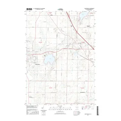
2015 Map of Hartford East
USGS Topo · Published 2015About this map
The glacial topography of the Kettle Moraine dominates this area of Washington County, where the rising city of Hartford and the village of Slinger anchor a landscape defined by significant freshwater bodies. The western edge is shaped by the Rubicon River and the Hartford Millpond, while Pike Lake and Cedar Lake highlight the recreational and ecological character of the region. Smaller rural nodes like Saint Lawrence, Ackerville, and Diefenbach Corners represent the persistent agricultural and small-town framework of the mid-20th century. Local history and genealogy are preserved at sites like Saint Pauls Cemetery and Union Cemetery. The map also traces the winding courses of the Ashippun River and Coney River, illustrating how the waterway network influenced early development and transportation routes between these Wisconsin communities.
Find a feature on this map
79 named features on this map. Tap any name to fly to it.
Don’t see what you’re looking for? This feature index may not catch every label — zoom into the map to look around manually.
Map Details
Editions of this 2015 Hartford East Map
This is the sole edition of this map. No revisions or reprints were ever made.
Other maps of this area

1892 · Waukesha
USGS Topo · 1:62,500

1892 · Oconomowoc
USGS Topo · 1:62,500

1901 · Waukesha
USGS Topo · 1:62,500

1904 · West Bend
USGS Topo · 1:62,500

1904 · Hartford
USGS Topo · 1:62,500

1906 · Waukesha
USGS Topo · 1:62,500

1909 · Oconomowoc
USGS Topo · 1:62,500

1957 · Madison
USGS Topo · 1:250,000

1959 · West Bend
USGS Topo · 1:62,500
1959 · Stonebank
USGS Topo · 1:24,000