
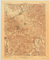
1909 Map of Hartford
USGS Topo · Published 1909About this map
Hartford and the surrounding Ohio County coalfields sit at a commercial crossroads in this early twentieth-century survey. The landscape is defined by the winding paths of the Rough River and Green River, where numerous historical crossings like Stroud Ferry, Snell Ferry, and Austins Ferry still facilitated local travel before modern bridging. The industrial heart of the region is centered on the Louisville and Nashville (Memphis Line) railroad, which connects the mining operations at Taylor Mines, Render, and McHenry.
Find a feature on this map
82 named features on this map. Tap any name to fly to it.
Don’t see what you’re looking for? This feature index may not catch every label — zoom into the map to look around manually.
Map Details
Editions of this 1909 Hartford Map
2 editions found
Other maps of this area

1906 · Sutherland
USGS Topo · 1:62,500

1907 · Whitesville
USGS Topo · 1:62,500

1909 · Whitesville
USGS Topo · 1:62,500

1909 · Central City
USGS Topo · 1:62,500

1911 · Drakesboro
USGS Topo · 1:48,000

1911 · Dunmor
USGS Topo · 1:48,000

1913 · Drakesboro
USGS Topo · 1:62,500

1914 · Little Muddy
USGS Topo · 1:62,500

1914 · Dunmor
USGS Topo · 1:62,500

1925 · Spring Lick
USGS Topo · 1:62,500