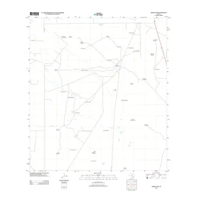
2012 Map of Hartland
USGS Topo · Published 2012About this map
The vast grazing lands of Hidalgo County dominate this landscape, where the settlement of Hartland and the Coyote Ranch serve as primary points of human activity. The map reveals a sophisticated network of ranching infrastructure, characterized by numerous named windmills that facilitate water access across the semi-arid terrain. Notable landmarks include the El Coyote Ranch Airport and large designated grazing tracts such as Patitos Pasture, Fant Pasture, and Marrana Pasture. Water features are sparse but critical, represented by the winding course of Vargas Cr and the waters of Tasajal Lake. Transport through this remote section of South Texas is anchored by US Highway 281 and county roads like Co RD 310, connecting these isolated ranching outposts to the broader region.
Find a feature on this map
38 named features on this map. Tap any name to fly to it.
Don’t see what you’re looking for? This feature index may not catch every label — zoom into the map to look around manually.
Map Details
Editions of this 2012 Hartland Map
This is the sole edition of this map. No revisions or reprints were ever made.
Other maps of this area

1939 · Linn
USGS Topo · 1:62,500

1939 · La Reforma
USGS Topo · 1:62,500

1939 · Encantada
USGS Topo · 1:62,500

1949 · Mc Allen
USGS Topo · 1:250,000

1954 · McAllen
USGS Topo · 1:250,000

1957 · Mc Allen
USGS Topo · 1:250,000

1962 · McAllen
USGS Topo · 1:250,000
1963 · Callo Padrones
USGS Topo · 1:24,000
1963 · Encino
USGS Topo · 1:24,000

1963 · Linn NW
USGS Topo · 1:24,000