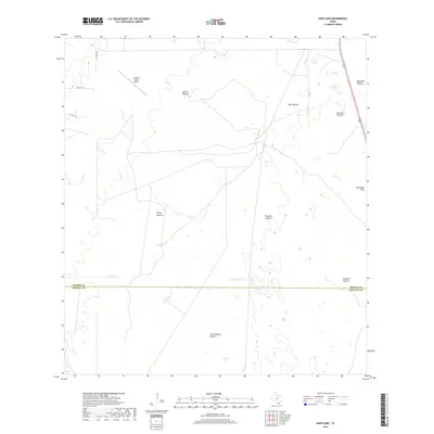
2019 Map of Hartland
USGS Topo · Published 2019About this map
El Coyote Ranch Airport sits at the northern edge of a landscape defined by extensive ranching divisions and pastoral tracts in the South Texas brush country. This 2019 survey captures the managed terrain near the Brooks and Hidalgo county line, where the land is partitioned into distinct named zones such as Fant Pasture, Palomas Pasture, and Vargas Pasture. The sparse drainage network is represented by the ephemeral Vargas Cr and the waters of Tasajal Lake, highlighting the critical importance of water management in this arid region.
Find a feature on this map
17 named features on this map. Tap any name to fly to it.
Don’t see what you’re looking for? This feature index may not catch every label — zoom into the map to look around manually.
Map Details
Editions of this 2019 Hartland Map
This is the sole edition of this map. No revisions or reprints were ever made.
Other maps of this area

1939 · Linn
USGS Topo · 1:62,500

1939 · La Reforma
USGS Topo · 1:62,500

1939 · Encantada
USGS Topo · 1:62,500

1949 · Mc Allen
USGS Topo · 1:250,000

1954 · McAllen
USGS Topo · 1:250,000

1957 · Mc Allen
USGS Topo · 1:250,000

1962 · McAllen
USGS Topo · 1:250,000
1963 · Callo Padrones
USGS Topo · 1:24,000
1963 · Encino
USGS Topo · 1:24,000

1963 · Linn NW
USGS Topo · 1:24,000