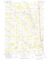
1968 Map of Hartland
USGS Topo · Published 1976About this map
North Ore Creek winds through this central Michigan landscape, connecting a network of glacial lakes including Shannon Lake, Brophy Lake, and Neff Lake. Small rural clusters like Deerfield Center and Parshallville serve as local anchors for the surrounding townships of Deerfield, Tyrone, Oceola, and Hartland. The map reveals a community defined by its quiet country roads and spiritual landmarks, such as Hardy Ch, St Augustine Ch, and St John Ch. Evidence of local industry appears in the numerous Gravel Pits and Sandpits scattered across the terrain, while the Deerfield Center Cem provides a point of interest for genealogists tracing local families. This mid-century survey also notes a Youth Camp and a major utility Pipeline cutting through the farmland, illustrating the balance between recreational land use and expanding infrastructure in Livingston County.
Find a feature on this map
42 named features on this map. Tap any name to fly to it.
Don’t see what you’re looking for? This feature index may not catch every label — zoom into the map to look around manually.
Map Details
Editions of this 1968 Hartland Map
2 editions found
Other maps of this area

1907 · Howell
USGS Topo · 1:62,500

1909 · Howell
USGS Topo · 1:62,500

1909 · Milford
USGS Topo · 1:62,500

1920 · Holly
USGS Topo · 1:62,500

1922 · Holly
USGS Topo · 1:62,500

1922 · Durand
USGS Topo · 1:62,500

1943 · Holly
USGS Topo · 1:62,500

1943 · Durand
USGS Topo · 1:62,500

1954 · Detroit
USGS Topo · 1:250,000

1961 · Detroit
USGS Topo · 1:250,000
Featured Places
- Hartland Township, MI
- Oceola Township, MI
- Tyrone Township, MI
- Deerfield Township, MI
- Deerfield Center, Deerfield Township