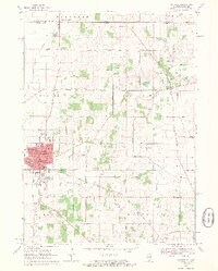
1970 Map of Harvard
USGS Topo · Published 1972About this map
Harvard serves as the industrial and civic anchor of this 1970 survey, where the Chicago and North Western rail line bisects the landscape. The city’s urban footprint is detailed with individual landmark buildings, including a Hospital, City Hall, and several local schools like Central Sch and Jefferson Sch. Surrounding the town, the rural character of McHenry County is defined by an extensive network of gravel operations and small farm-to-market roads such as Altenburg Road and Oak Grove Road.
Find a feature on this map
52 named features on this map. Tap any name to fly to it.
Don’t see what you’re looking for? This feature index may not catch every label — zoom into the map to look around manually.
Map Details
Editions of this 1970 Harvard Map
2 editions found
Other maps of this area

1893 · Delavan
USGS Topo · 1:62,500

1893 · Geneva
USGS Topo · 1:62,500

1904 · Lake Geneva
USGS Topo · 1:62,500

1906 · Lake Geneva
USGS Topo · 1:62,500

1926 · Mc Henry
USGS Topo · 1:62,500

1932 · Harvard
USGS Topo · 1:48,000

1937 · Harvard
USGS Topo · 1:62,500

1944 · McHenry
USGS Topo · 1:62,500

1954 · Rockford
USGS Topo · 1:250,000

1955 · Rockford
USGS Topo · 1:250,000