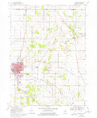
1970 Map of Harvard
USGS Topo · Published 1977About this map
Harvard serves as the primary urban center on this northern Illinois landscape, positioned at a vital junction of the Chicago and North Western railroad. The 1970s expansion of the town is visible through purple photorevisions, showing development around High Sch, St Joseph Ch, and the local Hospital. To the northeast, the smaller settlement of Alden sits among numerous Gravel Pits, illustrating the local extractive industry that defines the glacial terrain.
Find a feature on this map
65 named features on this map. Tap any name to fly to it.
Don’t see what you’re looking for? This feature index may not catch every label — zoom into the map to look around manually.
Map Details
Editions of this 1970 Harvard Map
2 editions found
Other maps of this area

1893 · Delavan
USGS Topo · 1:62,500

1893 · Geneva
USGS Topo · 1:62,500

1904 · Lake Geneva
USGS Topo · 1:62,500

1906 · Lake Geneva
USGS Topo · 1:62,500

1926 · Mc Henry
USGS Topo · 1:62,500

1932 · Harvard
USGS Topo · 1:48,000

1937 · Harvard
USGS Topo · 1:62,500

1944 · McHenry
USGS Topo · 1:62,500

1954 · Rockford
USGS Topo · 1:250,000

1955 · Rockford
USGS Topo · 1:250,000