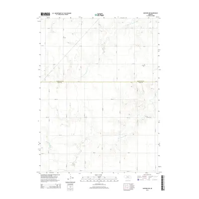
2014 Map of Harvard NW
USGS Topo · Published 2014About this map
The boundary between Hamilton Co and Clay Co bisects a landscape defined by the upper reaches of the Big Blue River system. This agricultural expanse is marked by the winding paths of the W Fork Big Blue River and the N Br W Fork Big Blue River, which carve subtle drainage patterns through the section-line road grid. For those tracing family history in this part of Nebraska, the map identifies several local landmarks, including the Case Cem, Greenwood Cem, and the First Evangelical Cem. The presence of the Bish Reservoir in the northwest corner suggests the ongoing importance of water management in this rural corridor. This modern survey provides an exact record of the persistent local road network, from 1st St to various numeric routes like Road 41 and Road 323, preserving the locations of rural cemeteries that are often the last physical remains of early farming communities.
Find a feature on this map
19 named features on this map. Tap any name to fly to it.
Don’t see what you’re looking for? This feature index may not catch every label — zoom into the map to look around manually.
Map Details
Editions of this 2014 Harvard NW Map
This is the sole edition of this map. No revisions or reprints were ever made.
Other maps of this area

1892 · Grand Island
USGS Topo · 1:62,500

1895 · Grand Island
USGS Topo · 1:62,500

1898 · Grand Island
USGS Topo · 1:125,000

1955 · Grand Island
USGS Topo · 1:250,000

1957 · Grand Island
USGS Topo · 1:250,000

1958 · Grand Island
USGS Topo · 1:250,000
1962 · Doniphan
USGS Topo · 1:24,000
1967 · Giltner
USGS Topo · 1:24,000
1968 · Aurora West
USGS Topo · 1:24,000

1969 · Hastings East
USGS Topo · 1:24,000