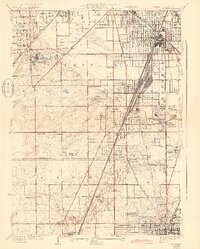
1929 Map of Harvey
USGS Topo · Published 1943About this map
Markham Yards dominates the central landscape of this southern Cook County corridor, illustrating the massive rail infrastructure that defined the region's industrial growth. Between the established streets of Harvey and the open grounds of Markham, the intricate track networks of the Illinois Central and Grand Trunk Western converge. To the west, the Oak Forest Institutions occupy a large campus, while the southern reaches near Chicago Heights show the suburban expansion into former farmland, marked by numerous private grounds like the Olympia Fields Country Club and the Washington Park Race Course.
Find a feature on this map
62 named features on this map. Tap any name to fly to it.
Don’t see what you’re looking for? This feature index may not catch every label — zoom into the map to look around manually.
Map Details
Editions of this 1929 Harvey Map
4 editions found

Other maps of this area

1890 · Des Plaines
USGS Topo · 1:62,500

1892 · Calumet
USGS Topo · 1:62,500

1893 · Calumet
USGS Topo · 1:62,500

1894 · Des Plaines
USGS Topo · 1:62,500

1900 · Des Plaines
USGS Topo · 1:62,500

1900 · Calumet
USGS Topo · 1:62,500

1901 · Calumet
USGS Topo · 1:62,500

1901 · Des Plaines
USGS Topo · 1:62,500

1928 · Palos Park
USGS Topo · 1:24,000

1929 · Tinley Park
USGS Topo · 1:24,000