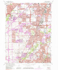
1963 Map of Harvey
USGS Topo · Published 1984About this map
The Thornton Quarry dominates the industrial landscape of this southern Cook County region, positioned between Harvey and Homewood. During the 1960s and 1970s, this area witnessed intensive suburban expansion, with the purple-tinted urban extensions reaching into Olympia Fields, Matteson, and Country Club Hills. A dense network of transportation infrastructure, including the Illinois Central railroad and the Tri-State Tollway, connects the established residential cores of Flossmoor and Glenwood with larger manufacturing centers.
Find a feature on this map
107 named features on this map. Tap any name to fly to it.
Don’t see what you’re looking for? This feature index may not catch every label — zoom into the map to look around manually.
Map Details
Editions of this 1963 Harvey Map
3 editions found

Other maps of this area

1890 · Des Plaines
USGS Topo · 1:62,500

1892 · Calumet
USGS Topo · 1:62,500

1893 · Calumet
USGS Topo · 1:62,500

1894 · Des Plaines
USGS Topo · 1:62,500

1900 · Des Plaines
USGS Topo · 1:62,500

1900 · Calumet
USGS Topo · 1:62,500

1901 · Calumet
USGS Topo · 1:62,500

1901 · Des Plaines
USGS Topo · 1:62,500

1928 · Palos Park
USGS Topo · 1:24,000

1929 · Tinley Park
USGS Topo · 1:24,000