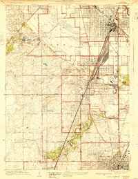
1929 Map of Harvey
USGS Topo · Published 1929About this map
Markham Yards and the convergence of several major railroads, including the Illinois Central and the Grand Trunk Western Ry, define the industrial and transportation character of this South Side Chicago suburban landscape in the late 1920s. The dense grid of Harvey and South Holland contrasts with the specialized campuses and recreational spaces nearby, such as the Oak Forest Institutions and several golf clubs like the Idlewild Country Club. The map reveals a transition from developed town centers to open land, documented here just as the Lincoln Highway was establishing itself as a primary corridor through Olympia Fields and Chicago Heights. Local history details include several schools like Stahl Sch and St Johns Sch, and recreational landmarks such as the Washington Park Race Course and the Illinois Kennel Club.
Find a feature on this map
63 named features on this map. Tap any name to fly to it.
Don’t see what you’re looking for? This feature index may not catch every label — zoom into the map to look around manually.
Map Details
Editions of this 1929 Harvey Map
4 editions found

Other maps of this area

1890 · Des Plaines
USGS Topo · 1:62,500

1892 · Calumet
USGS Topo · 1:62,500

1893 · Calumet
USGS Topo · 1:62,500

1894 · Des Plaines
USGS Topo · 1:62,500

1900 · Des Plaines
USGS Topo · 1:62,500

1900 · Calumet
USGS Topo · 1:62,500

1901 · Calumet
USGS Topo · 1:62,500

1901 · Des Plaines
USGS Topo · 1:62,500

1928 · Palos Park
USGS Topo · 1:24,000

1929 · Tinley Park
USGS Topo · 1:24,000