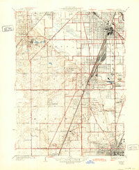
1929 Map of Harvey
USGS Topo · Published 1943About this map
Markham Yards dominates the industrial landscape of Cook County on this revised 1940s survey, illustrating the massive rail infrastructure that defined the region south of Chicago. The extensive yard system and the Illinois Central RR corridor serve as a spine for growing suburbs like Harvey, Homewood, and Flossmoor. The map captures a unique mix of social and recreational land use, from the Oak Forest Institutions and Glenwood Manual Training School to a high concentration of private clubs, including the Ravisloe Country Club and Idlewild Country Club. Cultural landmarks of the era are clearly marked, such as the Washington Park Race Course and the Illinois Kennel Club. Between these developed areas, the terrain of the Pottawattamie Hills and the winding course of Butterfield Creek provide a natural contrast to the rigid grid of streets and the Calumet Union Drainage canal.
Find a feature on this map
58 named features on this map. Tap any name to fly to it.
Don’t see what you’re looking for? This feature index may not catch every label — zoom into the map to look around manually.
Map Details
Editions of this 1929 Harvey Map
4 editions found

Other maps of this area

1890 · Des Plaines
USGS Topo · 1:62,500

1892 · Calumet
USGS Topo · 1:62,500

1893 · Calumet
USGS Topo · 1:62,500

1894 · Des Plaines
USGS Topo · 1:62,500

1900 · Des Plaines
USGS Topo · 1:62,500

1900 · Calumet
USGS Topo · 1:62,500

1901 · Calumet
USGS Topo · 1:62,500

1901 · Des Plaines
USGS Topo · 1:62,500

1928 · Palos Park
USGS Topo · 1:24,000

1929 · Tinley Park
USGS Topo · 1:24,000