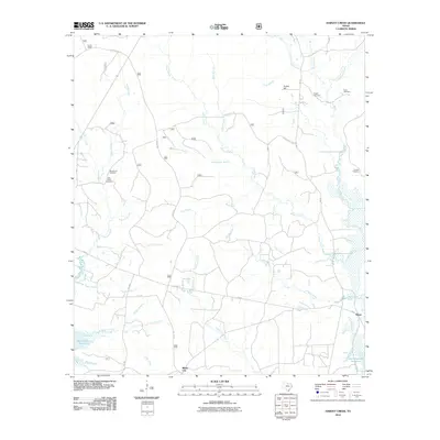
2010 Map of Harvey Creek
USGS Topo · Published 2010About this map
White City and the northern reaches of the Sam Rayburn Reservoir define this East Texas landscape, where the local terrain is carved by an intricate network of waterways. The topography is dominated by numerous drainages such as Ayish Bayou, Sandy Creek, and Harvey Creek, which flow southward toward the reservoir. Local history is preserved in several family and community burial sites, including Macedonia Cemetery, Nath Beck Cemetery, and Pisgah Cemetery, often found near old road alignments like Turkeyhill Rd.
Find a feature on this map
43 named features on this map. Tap any name to fly to it.
Don’t see what you’re looking for? This feature index may not catch every label — zoom into the map to look around manually.
Map Details
Editions of this 2010 Harvey Creek Map
This is the sole edition of this map. No revisions or reprints were ever made.
Other maps of this area

1931 · Zavalla
USGS Topo · 1:62,500

1953 · Palestine
USGS Topo · 1:250,000

1957 · Palestine
USGS Topo · 1:250,000

1958 · Zavalla
USGS Topo · 1:62,500

1958 · Broaddus
USGS Topo · 1:62,500

1958 · Mc Gee Bend
USGS Topo · 1:62,500

1958 · Bronson
USGS Topo · 1:62,500

1984 · Norwood
USGS Topo · 1:24,000
1984 · Veach
USGS Topo · 1:24,000
1984 · Chireno South
USGS Topo · 1:24,000