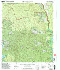
2003 Map of Harvey Creek
USGS Topo · Published 2004About this map
Angelina National Forest dominates this San Augustine County landscape, where the deeply dissected terrain of the Turkey Hill Wilderness meets the eastern shores of the Sam Rayburn Reservoir. The map documents a sparsely populated timberland region defined by its dense network of waterways, including Ayish Bayou, Turkey Creek, and Harvey Creek. Human settlement is concentrated in small communities such as White City and Macedonia, which are anchored by long-standing local landmarks like the Macedonia Cem. The presence of numerous family and community burial sites, including Nath Beck Cem and Crocker Cem, offers significant detail for genealogical research. To the southeast, the inundation of the Sam Rayburn Reservoir has reshaped the original drainage patterns of Cedar Creek and Little Creek, creating a complex shoreline that characterizes the modern geography of the area.
Find a feature on this map
39 named features on this map. Tap any name to fly to it.
Don’t see what you’re looking for? This feature index may not catch every label — zoom into the map to look around manually.
Map Details
Editions of this 2003 Harvey Creek Map
This is the sole edition of this map. No revisions or reprints were ever made.
Other maps of this area

1931 · Zavalla
USGS Topo · 1:62,500

1953 · Palestine
USGS Topo · 1:250,000

1957 · Palestine
USGS Topo · 1:250,000

1958 · Zavalla
USGS Topo · 1:62,500

1958 · Broaddus
USGS Topo · 1:62,500

1958 · Mc Gee Bend
USGS Topo · 1:62,500

1958 · Bronson
USGS Topo · 1:62,500

1984 · Norwood
USGS Topo · 1:24,000
1984 · Veach
USGS Topo · 1:24,000
1984 · Chireno South
USGS Topo · 1:24,000