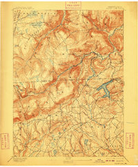
1893 Map of Harvey Lake
USGS Topo · Published 1909About this map
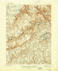
Dutch Mountain and Fork Mountain dominate the rugged northern landscape of this 1891 survey, where the Lehigh Valley R.R. follows the narrow corridor of Bowman Creek through Noxen. This industrial and wilderness topography reveals a region defined by its timber and water resources, with early lumbering interests signaled by Lewis Run and Bear Hollow. To the southeast, the terrain softens around the prominent waters of Harvey Lake, a focal point for early recreation and local settlement near Alderson and Laketon. Family-named landmarks like Cease Mills and Rittenhouse dot the lower valleys of Sweet Valley and Pike Creek, providing a clear view of the rural township structure before the expansion of modern transport. The map documents the intricate network of brooks and swamps, including Crane Swamp and Tamarack Swamp, that fed the high-elevation watersheds of the late nineteenth century.
Find a feature on this map
80 named features on this map. Tap any name to fly to it.
Don’t see what you’re looking for? This feature index may not catch every label — zoom into the map to look around manually.
Map Details
Editions of this 1893 Harvey Lake Map
6 editions found
Other maps of this area

1891 · Wilkesbarre
USGS Topo · 1:62,500

1891 · Harveys Lake
USGS Topo · 1:62,500

1893 · Harvey Lake
USGS Topo · 1:62,500

1893 · Pittston
USGS Topo · 1:62,500

1894 · Shickshinny
USGS Topo · 1:62,500

1894 · Bloomsburg
USGS Topo · 1:62,500

1894 · Wilkesbarre
USGS Topo · 1:62,500

1934 · Laporte
USGS Topo · 1:62,500

1943 · Scranton
USGS Topo · 1:125,000

1943 · Monroeton
USGS Topo · 1:62,500