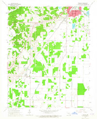
1964 Map of Harviell
USGS Topo · Published 1965About this map
Harviell and Angus anchor this mid-1960s survey of southern Butler County, where the lowlands meet the rising topography of the Beaver Dam area. The landscape is defined by its complex drainage network, including Cane Creek, Black Creek, and the Black River, which flows past the southern reaches of Poplar Bluff. The presence of the St Louis-San Francisco and Missouri Pacific railroads underscores the region's historical reliance on rail transport for both passengers and the local timber or agricultural economy.
Find a feature on this map
38 named features on this map. Tap any name to fly to it.
Don’t see what you’re looking for? This feature index may not catch every label — zoom into the map to look around manually.
Map Details
Editions of this 1964 Harviell Map
Other maps of this area

1934 · Williamsville
USGS Topo · 1:48,000

1935 · Poplar Bluff
USGS Topo · 1:62,500

1935 · Acorn
USGS Topo · 1:62,500

1935 · Harviell
USGS Topo · 1:62,500

1939 · Poplar Bluff
USGS Topo · 1:62,500

1940 · Williamsville
USGS Topo · 1:62,500

1940 · Naylor
USGS Topo · 1:62,500

1944 · Naylor
USGS Topo · 1:62,500

1949 · Poplar Bluff
USGS Topo · 1:62,500

1957 · Poplar Bluff
USGS Topo · 1:250,000