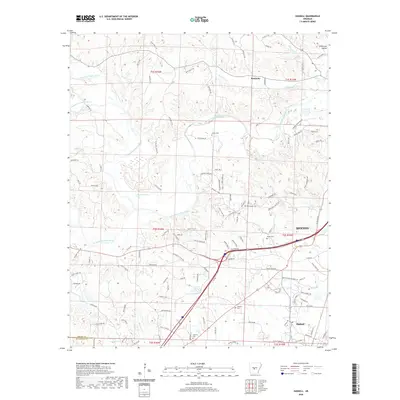
2020 Map of Haskell
USGS Topo · Published 2020About this map
The confluence of the Alum Fork Saline River and South Fork Saline River defines this portion of Saline County, where modern infrastructure meets long-standing family landholdings. To the east, the edge of Benton and the community of Haskell mark the transition toward more developed terrain, while the settlement of Kentucky remains situated among the northern creek valleys. For genealogists and local historians, the landscape is punctuated by numerous family burial grounds, including James Cem, Hammonds Cem, and Winters Cem, which are often the last physical markers of the area's earliest homesteads. The terrain is a network of watercourses such as Trace Cr and Clift Cr, which have historically dictated the placement of rural roads like Davis Wells Rd and Nickel Bill James Rd. From the waters of Masoner Lake to the secluded Stillhouse Hollow, the map provides a contemporary view of these established central Arkansas communities.
Find a feature on this map
127 named features on this map. Tap any name to fly to it.
Don’t see what you’re looking for? This feature index may not catch every label — zoom into the map to look around manually.
Map Details
Editions of this 2020 Haskell Map
This is the sole edition of this map. No revisions or reprints were ever made.
Other maps of this area

1890 · Benton
USGS Topo · 1:125,000

1894 · Benton
USGS Topo · 1:125,000

1938 · Benton
USGS Topo · 1:48,000

1944 · Benton
USGS Topo · 1:62,500

1944 · Benton
USGS Topo · 1:31,680

1948 · Malvern
USGS Topo · 1:62,500

1949 · Malvern
USGS Topo · 1:62,500

1955 · Little Rock
USGS Topo · 1:250,000

1956 · Little Rock
USGS Topo · 1:250,000

1960 · Little Rock
USGS Topo · 1:250,000