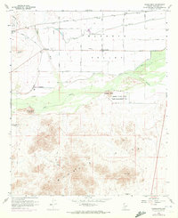
1958 Map of Hassayampa
USGS Topo · Published 1972About this map
Agricultural development and desert mining define this landscape where the Hassayampa River joins the Gila River. The irrigation infrastructure of the Buckeye Valley is on full display, with the Buckeye Canal and Arlington Canal drawing water to support settlements like Hassayampa, Palo Verde, and Dixie. To the south, the terrain rises sharply into the Buckeye Hills, a stark contrast to the floodplains protected by the Gila Levee and Buckeye Levee.
Find a feature on this map
33 named features on this map. Tap any name to fly to it.
Don’t see what you’re looking for? This feature index may not catch every label — zoom into the map to look around manually.
Map Details
Editions of this 1958 Hassayampa Map
4 editions found
Other maps of this area

1951 · Cotton Center
USGS Topo · 1:62,500

1951 · Woolsey Peak
USGS Topo · 1:62,500

1954 · Phoenix
USGS Topo · 1:250,000

1957 · Phoenix
USGS Topo · 1:250,000

1957 · Valencia
USGS Topo · 1:24,000

1958 · Phoenix
USGS Topo · 1:250,000

1958 · Buckeye NW
USGS Topo · 1:24,000

1958 · Hassayampa
USGS Topo · 1:24,000

1958 · Buckeye
USGS Topo · 1:24,000

1958 · Buckeye
USGS Topo · 1:62,500