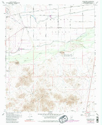
1958 Map of Hassayampa
USGS Topo · Published 1983About this map
The confluence of the Hassayampa River and the Gila River defines the irrigation-dependent landscape of this Maricopa County region. In the late 1950s, the Buckeye Valley supported a complex network of water management, including the Buckeye Canal, the Lower River Road Canal, and a prominent Siphon system. These engineering efforts allowed agricultural settlements like Hassayampa and Palo Verde to thrive alongside the Southern Pacific tracks.
Find a feature on this map
39 named features on this map. Tap any name to fly to it.
Don’t see what you’re looking for? This feature index may not catch every label — zoom into the map to look around manually.
Map Details
Editions of this 1958 Hassayampa Map
4 editions found
Other maps of this area

1951 · Cotton Center
USGS Topo · 1:62,500

1951 · Woolsey Peak
USGS Topo · 1:62,500

1954 · Phoenix
USGS Topo · 1:250,000

1957 · Phoenix
USGS Topo · 1:250,000

1957 · Valencia
USGS Topo · 1:24,000

1958 · Phoenix
USGS Topo · 1:250,000

1958 · Buckeye NW
USGS Topo · 1:24,000

1958 · Hassayampa
USGS Topo · 1:24,000

1958 · Buckeye
USGS Topo · 1:24,000

1958 · Buckeye
USGS Topo · 1:62,500