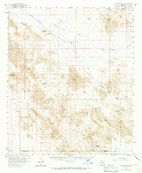
1958 Map of Hat Mountain
USGS Topo · Published 1965About this map
Sauceda Mountains and the Sand Tank Mountains dominate this high-desert landscape in the late 1950s, defining a region where water management was essential for survival and navigation. The map documents a network of vital water sources including Platt Well, Pottebaum Tank, and Javelina Tank, which served as critical landmarks for travelers and locals alike. Drainage patterns like Sauceda Wash and Quilotosa Wash cut through the terrain, illustrating the seasonal water flow that shaped the area's geography.
Find a feature on this map
32 named features on this map. Tap any name to fly to it.
Don’t see what you’re looking for? This feature index may not catch every label — zoom into the map to look around manually.
Map Details
Editions of this 1958 Hat Mountain Map
3 editions found

Other maps of this area

1932 · Ajo
USGS Topo · 1:62,500

1934 · Ajo
USGS Topo · 1:62,500

1950 · Theba
USGS Topo · 1:62,500

1951 · Estrella
USGS Topo · 1:62,500

1951 · Gila Bend
USGS Topo · 1:62,500

1951 · Theba
USGS Topo · 1:62,500

1953 · Ajo
USGS Topo · 1:250,000

1957 · Ajo
USGS Topo · 1:250,000

1958 · Ajo
USGS Topo · 1:250,000

1958 · Kaka
USGS Topo · 1:62,500