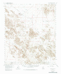
1958 Map of Hat Mountain
USGS Topo · Published 1979About this map
The Sauceda Mountains dominate this high-desert landscape in southern Arizona, a region defined in the late 1950s by its vast military and tribal holdings. The map reveals the intersection of the Luke Air Force Range and the Papago Indian Reservation, highlighting the area's strategic and indigenous history. Settlement is sparse, represented by the remote Midway and the archaeological footprint of Chiulikam (Site). Water management is critical in this arid environment, evidenced by named features like Butte Tank, Pottebaum Tank, and Platt Well. Prominent peaks such as Hat Mtn, Black Butte, and Stinson Peak provide essential navigation landmarks across the network of desert washes, including Quilotosa Wash and Sauceda Wash. A network of jeep trails indicates the rugged accessibility of the terrain before later modern developments altered the character of this desert expanse.
Find a feature on this map
23 named features on this map. Tap any name to fly to it.
Don’t see what you’re looking for? This feature index may not catch every label — zoom into the map to look around manually.
Map Details
Editions of this 1958 Hat Mountain Map
3 editions found

Other maps of this area

1932 · Ajo
USGS Topo · 1:62,500

1934 · Ajo
USGS Topo · 1:62,500

1950 · Theba
USGS Topo · 1:62,500

1951 · Estrella
USGS Topo · 1:62,500

1951 · Gila Bend
USGS Topo · 1:62,500

1951 · Theba
USGS Topo · 1:62,500

1953 · Ajo
USGS Topo · 1:250,000

1957 · Ajo
USGS Topo · 1:250,000

1958 · Ajo
USGS Topo · 1:250,000

1958 · Kaka
USGS Topo · 1:62,500