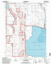
1993 Map of Hatfield
USGS Topo · Published 1997About this map
Sheepy Ridge dominates this northern California borderland, dividing a complex landscape of managed wetlands and reclaimed agricultural flats. This 1990s revision shows the intricate network of the Lower Klamath National Wildlife Refuge and Tule Lake Nat Wildlife Refuge, where the Tule Lake Sump and Lost River define the local hydrology. The small community of Hatfield sits at the northern edge along the Southern Pacific rail line, marking a critical crossing between Siskiyou County and Oregon. The map detail highlights an intensive water management system, featuring the Brimmer Canal, numerous levees, and the Tule Lake Tunnel. These features, along with family-named roads like Kandra Road and Fensler Road, reveal how the high desert terrain was engineered for both conservation and settlement during the late twentieth century.
Find a feature on this map
35 named features on this map. Tap any name to fly to it.
Don’t see what you’re looking for? This feature index may not catch every label — zoom into the map to look around manually.
Map Details
Editions of this 1993 Hatfield Map
This is the sole edition of this map. No revisions or reprints were ever made.
Other maps of this area

1886 · Modoc Lava Bed
USGS Topo · 1:250,000

1889 · Klamath
USGS Topo · 1:250,000

1892 · Modoc Lava-Bed
USGS Topo · 1:250,000

1894 · Klamath
USGS Topo · 1:250,000

1950 · Mt. Dome
USGS Topo · 1:62,500

1951 · Tulelake
USGS Topo · 1:62,500

1954 · Alturas
USGS Topo · 1:250,000

1955 · Klamath Falls
USGS Topo · 1:250,000

1957 · Merrill
USGS Topo · 1:62,500

1957 · Malin
USGS Topo · 1:62,500