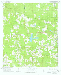
1965 Map of Hattiesburg SW
USGS Topo · Published 1977About this map
Hennington Lake sits at the heart of this landscape west of Hattiesburg, where the rural character of Lamar County was increasingly defined by its water resources and emerging infrastructure in the mid-1960s. The Mississippi Central corridor cuts across the northern terrain, connecting small communities like Clyde and Wardwell while serving as a backbone for the local economy. Genealogists and local historians will find a dense concentration of family landmarks and community anchors, including the Rawls Cem, Grantham Cem, and Forest Memorial Park Cem. Numerous country churches such as Oral Ch, New Zion Ch, Bellevue Ch, and Calvary Ch are distributed throughout the township, marking the social centers for residents living near the winding paths of Black Creek and Perkins Creek. The presence of several Gravel Pits and a prominent Pipeline illustrate the mid-century industrial activity that existed alongside established recreation sites like the Hattiesburg Country Club.
Find a feature on this map
33 named features on this map. Tap any name to fly to it.
Don’t see what you’re looking for? This feature index may not catch every label — zoom into the map to look around manually.
Map Details
Editions of this 1965 Hattiesburg SW Map
4 editions found
Other maps of this area

1953 · Hattiesburg
USGS Topo · 1:250,000

1958 · Hattiesburg
USGS Topo · 1:250,000

1964 · Purvis
USGS Topo · 1:24,000

1964 · Hattiesburg
USGS Topo · 1:24,000

1965 · Hattiesburg SW
USGS Topo · 1:24,000

1965 · Dixie
USGS Topo · 1:24,000

1965 · Eastabuchie
USGS Topo · 1:24,000

1965 · Sanford
USGS Topo · 1:24,000

1969 · Baxterville NE
USGS Topo · 1:24,000

1974 · Sumrall
USGS Topo · 1:24,000