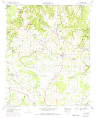
1948 Map of Hatton
USGS Topo · Published 1974About this map
Hatton and the surrounding Moulton Valley are documented here in a 1948 topographic study, with revisions extending into the early 1970s. The landscape is a mix of agricultural bottoms and the prominent rise of Black Ground Mountain and Mill Mtn to the north. For genealogists, the map is remarkably dense with family-named landmarks and cemeteries, including the Fergason Cem, Masterson Cem, and Roden Cem. Small community centers like Wolf Springs and Beavers Cross appear alongside established congregations at Providence Church and Okalona Church. The intricate drainage system of Town Creek and its many tributaries, such as Masterson Creek and Wolf Creek, define the rural geography. Modern infrastructure is represented by the Airway beacon near Oak Grove, while the local social fabric is evidenced by the Athletic field in Hatton.
Find a feature on this map
66 named features on this map. Tap any name to fly to it.
Don’t see what you’re looking for? This feature index may not catch every label — zoom into the map to look around manually.
Map Details
Editions of this 1948 Hatton Map
2 editions found
Other maps of this area

1924 · Tuscumbia
USGS Topo · 1:48,000

1926 · Tuscumbia
USGS Topo · 1:62,500

1935 · Moulton
USGS Topo · 1:24,000

1936 · Newburg
USGS Topo · 1:24,000

1936 · Courtland
USGS Topo · 1:24,000

1936 · Moulton
USGS Topo · 1:48,000

1936 · Town Creek
USGS Topo · 1:24,000
1936 · Leighton
USGS Topo · 1:24,000

1936 · Masterson
USGS Topo · 1:24,000

1936 · Hatton
USGS Topo · 1:24,000