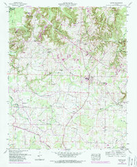
1948 Map of Hatton
USGS Topo · Published 1989About this map
Hatton and the surrounding Lawrence County uplands are documented here in a detailed landscape of family farms and small communities. The terrain transitions from the elevations of Black Ground Mountain and Mill Mtn in the north toward the gentler valley of Town Creek to the south. This area is characterized by a dense network of early rural institutions, including New Zion Ch, Okalona Church, and Harris Chapel, alongside numerous family-named burial grounds like Fergason Cem and Rutherford Cem.
Find a feature on this map
58 named features on this map. Tap any name to fly to it.
Don’t see what you’re looking for? This feature index may not catch every label — zoom into the map to look around manually.
Map Details
Editions of this 1948 Hatton Map
2 editions found
Other maps of this area

1924 · Tuscumbia
USGS Topo · 1:48,000

1926 · Tuscumbia
USGS Topo · 1:62,500

1935 · Moulton
USGS Topo · 1:24,000

1936 · Newburg
USGS Topo · 1:24,000

1936 · Courtland
USGS Topo · 1:24,000

1936 · Moulton
USGS Topo · 1:48,000

1936 · Town Creek
USGS Topo · 1:24,000
1936 · Leighton
USGS Topo · 1:24,000

1936 · Masterson
USGS Topo · 1:24,000

1936 · Hatton
USGS Topo · 1:24,000