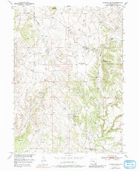
1950 Map of Haushar Ranch
USGS Topo · Published 1980About this map
Family-run livestock operations define this portion of Platte County at the mid-century, where the high-plains landscape is punctuated by isolated homesteads. Scattered along the drainages of Boxelder Creek and Patten Creek, name-bearing properties like McNutt Ranch, Ferguson Ranch, and Haushar Ranch represent the backbone of the local ranching economy. The map reveals a transition in rural education with the labeling of Canyon View School (Abandoned), signaling the shift toward consolidated school districts as the mid-1900s progressed.
Find a feature on this map
17 named features on this map. Tap any name to fly to it.
Don’t see what you’re looking for? This feature index may not catch every label — zoom into the map to look around manually.
Map Details
Editions of this 1950 Haushar Ranch Map
2 editions found
Other maps of this area

1896 · Hartville
USGS Topo · 1:125,000

1901 · Hartville
USGS Topo · 1:125,000

1949 · Cedar Top
USGS Topo · 1:24,000

1950 · Cedar Top
USGS Topo · 1:24,000

1950 · Jewel Springs
USGS Topo · 1:24,000

1950 · Guernsey
USGS Topo · 1:24,000

1950 · Herman Ranch
USGS Topo · 1:24,000

1950 · Haushar Ranch
USGS Topo · 1:24,000

1950 · Hell Gap
USGS Topo · 1:24,000

1950 · Guernsey Reservoir
USGS Topo · 1:24,000