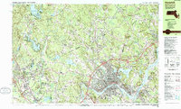
1985 Map of Haverhill
USGS Topo · Published 1986About this map
The Merrimack River serves as the industrial and geographical heart of this mid-1980s landscape, winding past the urban core of Haverhill and the neighboring community of Bradford. This era shows a region in transition, where the historic Boston and Maine RR and legacy landmarks like the Whittier Birthplace coexist with the modern expansion of Interstate 495. To the north, the landscape crosses the New Hampshire Massachusetts border, revealing a network of smaller villages such as Atkinson, Westville, and Plaistow. This cross-border connectivity is further emphasized by the numerous named hills like Parsonage Hill and Bragg Hill that define the local topography. Local educational and religious institutions, including the historic Atkinson Academy and Holy Angels Ch, provide essential touchpoints for genealogical research and the study of late 20th-century New England settlement patterns.
Find a feature on this map
103 named features on this map. Tap any name to fly to it.
Don’t see what you’re looking for? This feature index may not catch every label — zoom into the map to look around manually.
Map Details
Editions of this 1985 Haverhill Map
This is the sole edition of this map. No revisions or reprints were ever made.
Other maps of this area

1886 · Lawrence
USGS Topo · 1:62,500

1886 · Lowell
USGS Topo · 1:62,500

1888 · Newburyport
USGS Topo · 1:62,500

1888 · Haverhill
USGS Topo · 1:62,500

1888 · Lawrence
USGS Topo · 1:62,500

1888 · Salem
USGS Topo · 1:62,500

1890 · Haverhill
USGS Topo · 1:62,500

1890 · Newburyport
USGS Topo · 1:62,500

1893 · Lowell
USGS Topo · 1:62,500

1893 · Salem
USGS Topo · 1:62,500