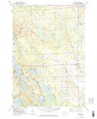
1971 Map of Hawks
USGS Topo · Published 1974About this map
Black Lake State Forest dominates this northern Michigan landscape, where the township boundaries of Moltke, Belknap, Bismarck, and Metz converge. The settlement of Hawks serves as a small hub along the Detroit and Mackinac Railroad, characterized by civic and religious infrastructure including the Hawks Sch, Faith Cem, and Hope Cem. The topography is defined by a dense network of glacial lakes such as Nettie Lake, Lake Louise, and Lake Emma, which are interspersed with cedar swamps and wetlands.
Find a feature on this map
46 named features on this map. Tap any name to fly to it.
Don’t see what you’re looking for? This feature index may not catch every label — zoom into the map to look around manually.
Map Details
Editions of this 1971 Hawks Map
2 editions found

Other maps of this area

1954 · Alpena
USGS Topo · 1:250,000

1955 · Atlanta
USGS Topo · 1:62,500

1955 · Hillman
USGS Topo · 1:62,500

1955 · Cheboygan
USGS Topo · 1:250,000

1957 · Alpena
USGS Topo · 1:250,000

1957 · Onaway
USGS Topo · 1:62,500

1958 · Cheboygan
USGS Topo · 1:250,000

1958 · Alpena
USGS Topo · 1:250,000

1969 · Alpena
USGS Topo · 1:250,000

1971 · Rogers City
USGS Topo · 1:24,000