
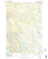
1971 Map of Hawks
USGS Topo · Published 1974About this map
The settlement of Hawks serves as the focal point for this northern Michigan landscape, situated along the line of the Detroit and Mackinac. This 1971 study reveals a region defined by its timber and water resources, with much of the terrain dedicated to the Black Lake State Forest. The local community is anchored by the Hawks Sch and a cluster of nearby burial grounds, including Hope Cem and Faith Cem, which provide valuable location data for genealogists tracking early families in Bismarck and Metz townships.
Find a feature on this map
48 named features on this map. Tap any name to fly to it.
Don’t see what you’re looking for? This feature index may not catch every label — zoom into the map to look around manually.
Map Details
Editions of this 1971 Hawks Map
2 editions found
Other maps of this area

1954 · Alpena
USGS Topo · 1:250,000

1955 · Atlanta
USGS Topo · 1:62,500

1955 · Hillman
USGS Topo · 1:62,500

1955 · Cheboygan
USGS Topo · 1:250,000

1957 · Alpena
USGS Topo · 1:250,000

1957 · Onaway
USGS Topo · 1:62,500

1958 · Cheboygan
USGS Topo · 1:250,000

1958 · Alpena
USGS Topo · 1:250,000

1969 · Alpena
USGS Topo · 1:250,000

1971 · Rogers City
USGS Topo · 1:24,000