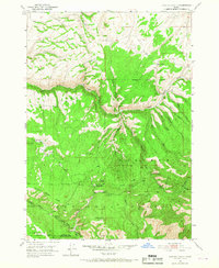
1951 Map of Hawley Gulch
USGS Topo · Published 1967About this map
Targhee National Forest dominates this mid-century Idaho landscape, where the high-altitude terrain is defined by complex drainage systems and isolated outposts. The Hawley Gulch Ranger Station and the Morning Glory Mine stand as the primary indicators of human activity, suggesting a seasonal economy based on resource extraction and forest management. The county line between Madison and Bonneville Counties cuts through the southern portion of the sheet near Lookout Mtn and Poison Flat.
Find a feature on this map
37 named features on this map. Tap any name to fly to it.
Don’t see what you’re looking for? This feature index may not catch every label — zoom into the map to look around manually.
Map Details
Editions of this 1951 Hawley Gulch Map
Other maps of this area

1943 · Garns Mtn
USGS Topo · 1:62,500

1946 · Garns Mtn
USGS Topo · 1:62,500

1951 · Moody
USGS Topo · 1:24,000

1951 · Poplar
USGS Topo · 1:24,000

1951 · Hawley Gulch
USGS Topo · 1:24,000

1951 · Heise
USGS Topo · 1:24,000

1951 · Heise SE
USGS Topo · 1:24,000

1951 · White Owl Butte
USGS Topo · 1:24,000

1955 · Driggs
USGS Topo · 1:250,000

1958 · Driggs
USGS Topo · 1:250,000