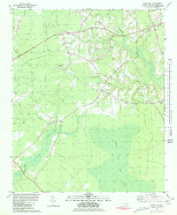
1981 Map of Haws Run
USGS Topo · Published 1981About this map
Great Sandy Run Pocosin dominates the southern landscape of this coastal plain region, illustrating the unique wetland ecology of Onslow County. The map documents a rural transition where traditional small-scale commerce at Waltons Store and small settlements like Cyrus and Padgett persist alongside modern aviation at Sky Manor Airport. A network of community landmarks is well-defined, particularly the concentration of rural houses of worship such as Harris Creek Ch, Pineland Ch, and New Dixon Ch. These institutions, alongside numerous unnamed family and church cemeteries, provide significant geographic anchors for genealogical research. Drainage patterns are meticulously captured through Harris Creek, Southwest Creek, and the headwaters of Haws Run, which serve as the primary topographical features defining property and community boundaries in this low-lying terrain.
Find a feature on this map
21 named features on this map. Tap any name to fly to it.
Don’t see what you’re looking for? This feature index may not catch every label — zoom into the map to look around manually.
Map Details
Editions of this 1981 Haws Run Map
2 editions found
Other maps of this area

1943 · Jacksonville
USGS Topo · 1:62,500

1948 · Maple Hill
USGS Topo · 1:62,500

1948 · New River
USGS Topo · 1:62,500

1948 · Richlands
USGS Topo · 1:62,500

1952 · Jacksonville South
USGS Topo · 1:24,000

1952 · Sneads Ferry
USGS Topo · 1:24,000

1953 · Beaufort
USGS Topo · 1:250,000

1954 · Beaufort
USGS Topo · 1:250,000

1965 · Richlands
USGS Topo · 1:62,500

1972 · Beaufort
USGS Topo · 1:250,000