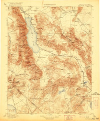
1911 Map of Hawthorne
USGS Topo · Published 1921About this map
Walker Lake dominates the high desert landscape of central Nevada in this early 20th-century survey, with the Walker River feeding in from the north near Schurz. The era's mining and transit economy is etched across the terrain, showing the Southern Pacific System and Tonopah and Goldfield RR connecting bustling camps and remote sidings. Notable mining-era settlements include Hawthorne, Aurora, and the rail junction at Mina.
Find a feature on this map
124 named features on this map. Tap any name to fly to it.
Don’t see what you’re looking for? This feature index may not catch every label — zoom into the map to look around manually.
Map Details
Editions of this 1911 Hawthorne Map
4 editions found

Other maps of this area

1891 · Wabuska
USGS Topo · 1:125,000

1891 · Wellington
USGS Topo · 1:125,000

1893 · Wellington
USGS Topo · 1:125,000

1894 · Wabuska
USGS Topo · 1:125,000

1898 · Silver Peak
USGS Topo · 1:125,000

1900 · Silver Peak
USGS Topo · 1:125,000

1901 · Mt. Lyell
USGS Topo · 1:125,000

1907 · Tonopah
USGS Topo · 1:250,000

1908 · Lida
USGS Topo · 1:250,000

1908 · Tonopah
USGS Topo · 1:250,000