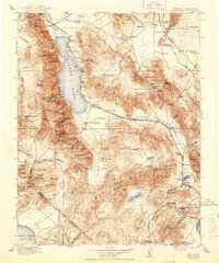
1911 Map of Hawthorne
USGS Topo · Published 1944About this map
Walker Lake dominates the western basin of this high-desert landscape, flanked by the massive Wassuk Range and its high peaks like Mt Grant. At the dawn of the 20th century, the regional economy was driven by a complex network of rail lines and mining outposts. The Southern Pacific System and Nevada and California RR connect vital centers like Hawthorne, Luning, and Mina. Further south, the map documents the decline and activity of silver and borax centers, including Candelaria, Belleville, and the lakeside operations at Rhodes Salt Marsh. High in the eastern ranges, the Gabbs Valley Range shelters remote camps such as Bovard and the Buckley Camp, while a significant Pipe Line cuts across Soda Spring Valley, tracing the industrial efforts to transport water and resources through these arid flats.
Find a feature on this map
157 named features on this map. Tap any name to fly to it.
Don’t see what you’re looking for? This feature index may not catch every label — zoom into the map to look around manually.
Map Details
Editions of this 1911 Hawthorne Map
4 editions found

Other maps of this area

1891 · Wabuska
USGS Topo · 1:125,000

1891 · Wellington
USGS Topo · 1:125,000

1893 · Wellington
USGS Topo · 1:125,000

1894 · Wabuska
USGS Topo · 1:125,000

1898 · Silver Peak
USGS Topo · 1:125,000

1900 · Silver Peak
USGS Topo · 1:125,000

1901 · Mt. Lyell
USGS Topo · 1:125,000

1907 · Tonopah
USGS Topo · 1:250,000

1908 · Lida
USGS Topo · 1:250,000

1908 · Tonopah
USGS Topo · 1:250,000