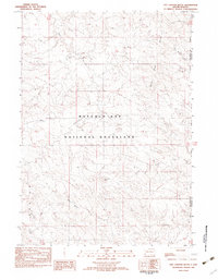
1982 Map of Hay Canyon Butte
USGS Topo · Published 1982About this map
Buffalo Gap National Grassland dominates this 1982 provisional survey, revealing a landscape defined by the rugged drainage systems of the White River. The topography is marked by significant elevations like Hay Canyon Butte and Kennedy Butte, which provide natural landmarks overlooking the intricate network of watercourses including Hay Canyon, Cortney Creek, and Rock Creek. This area of southwestern South Dakota illustrates the interface between public conservation land and the Pine Ridge Indian Reservation Boundary, which runs along the eastern edge. The map captures the transitional terrain of the Divide, where the land falls away into the Cedar Bluff Creek basin, showing a region preserved for its natural character and lack of dense modern development.
Find a feature on this map
11 named features on this map. Tap any name to fly to it.
Don’t see what you’re looking for? This feature index may not catch every label — zoom into the map to look around manually.
Map Details
Editions of this 1982 Hay Canyon Butte Map
This is the sole edition of this map. No revisions or reprints were ever made.
Other maps of this area

1896 · Oelrichs
USGS Topo · 1:125,000

1900 · Oelrichs
USGS Topo · 1:125,000

1951 · Willow Creek NW
USGS Topo · 1:24,000

1951 · Smithwick NE
USGS Topo · 1:24,000

1951 · Smithwick NW
USGS Topo · 1:24,000

1955 · Hot Springs
USGS Topo · 1:250,000

1967 · Slim Butte NW
USGS Topo · 1:24,000

1967 · Willow Creek SW
USGS Topo · 1:24,000
1982 · Smithwick
USGS Topo · 1:25,000
1982 · Oelrichs
USGS Topo · 1:25,000