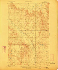
1912 Map of Hay Creek
USGS Topo · Published 1912About this map
The Fort Peck Indian Reservation defines this northern Montana landscape, surveyed in 1909 before the reservation was fully opened to homesteading. The terrain is characterized by a high, dissected plateau where the meandering Poplar River cuts a wide, alluvial valley through the center of the sheet. Human presence at this early date is sparse, centered on isolated holdings like Kirns Ranch situated along the riverbank. Drainage patterns are dominated by the eponymous Hay Creek and the western edge of Smoke Creek, illustrating the complex network of coulees and ridges that dictated early ranching routes and water access in Valley County. This survey by the General Land Office and the U.S. Geological Survey provides a precise record of the land just as it was being partitioned into townships and sections for future development.
Find a feature on this map
5 named features on this map. Tap any name to fly to it.
Don’t see what you’re looking for? This feature index may not catch every label — zoom into the map to look around manually.
Map Details
Editions of this 1912 Hay Creek Map
2 editions found
Other maps of this area

1909 · Smoke Creek
USGS Topo · 1:62,500

1910 · Cuskers
USGS Topo · 1:62,500

1912 · Chelsea
USGS Topo · 1:62,500

1912 · Hay Creek
USGS Topo · 1:62,500

1912 · Poplar
USGS Topo · 1:62,500

1912 · Smoke Creek
USGS Topo · 1:62,500

1914 · Brockton
USGS Topo · 1:62,500

1915 · Cuskers
USGS Topo · 1:62,500

1954 · Wolf Point
USGS Topo · 1:250,000

1958 · Wolf Point
USGS Topo · 1:250,000