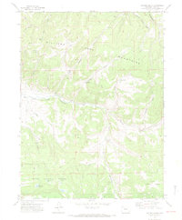
1971 Map of Hayden Gulch
USGS Topo · Published 1974About this map
The Williams Mountains dominate this high-altitude landscape in Routt National Forest, where the Williams Fork river system carves a complex network of canyons and gulches. In the early 1970s, this area of Colorado was a site of active resource extraction and water management, evidenced by the presence of a Strip Mine, several Mines, and numerous Drill Hole and Gas Well locations. The drainage patterns are meticulously recorded, showing how the East Fork Williams Fork meets a series of smaller tributaries like Wise Gulch, Card Gulch, and Lone Gulch. Cattle ranching and irrigation history are visible through numerous small-scale reservoirs and water features, including Dillabaugh Res, Detwiller Res, and the high-elevation Maud Wise Res. A Gaging Sta on the river and various Trails and Jeep Trails suggest a landscape used for both monitoring the watershed and supporting the seasonal needs of the regional timber and ranching economies.
Find a feature on this map
37 named features on this map. Tap any name to fly to it.
Don’t see what you’re looking for? This feature index may not catch every label — zoom into the map to look around manually.
Map Details
Editions of this 1971 Hayden Gulch Map
3 editions found
Other maps of this area

1916 · Daton Peak
USGS Topo · 1:62,500

1920 · Daton Peak
USGS Topo · 1:62,500

1924 · Mt. Harris
USGS Topo · 1:48,000

1926 · Mount Harris
USGS Topo · 1:62,500

1954 · Craig
USGS Topo · 1:250,000

1957 · Craig
USGS Topo · 1:250,000

1958 · Craig
USGS Topo · 1:250,000

1960 · Craig
USGS Topo · 1:250,000

1962 · Craig
USGS Topo · 1:250,000

1964 · Craig
USGS Topo · 1:250,000